It may also depend on the type of Drone you are using. That’s what we always say. Well, it is more complicated. There are different situations where you can sometimes fly higher, sometimes lower.
In the United States and many other countries, drones are legally limited to a maximum altitude of 400 feet above ground level. However, drones can technically reach altitudes up to 33,000 feet.
Let’s explore how high you can fly a drone as a recreational flyer when you’re flying for fun and how high you can fly if you’re flying as a remote pilot under part 107.
Two Different Sets of Rules for How High a Drone Can Fly
The reason why this is confusing is primarily because there are two different sets of rules that you can operate under in the United States.
- The first one is the recreational flying exemption USC 44809.
- The other one is kind of the primary set of rules in the US called part 107.
To operate under part 107, you need to take a written exam.
You need to pass that and then get a certificate from the FAA. And as such, because you have to take a test, there are opportunities to fly higher. They are more typical and higher than you would if you operated under 44. 809.
AGL and MSL Levels
Let’s talk about another confusing part, which is two terms.
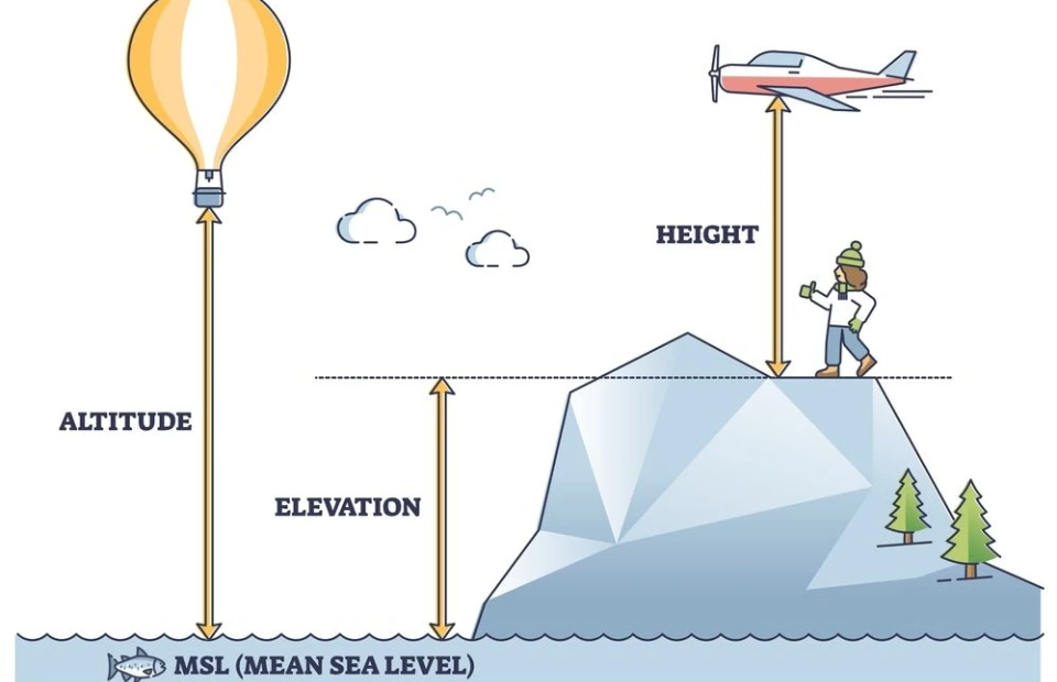
- The first term is called AGL, above ground level.
- The other term is called MSL, meaning sea level.
Some people call it above sea level. That’s not a term that we use in aviation, generally.
It’s the height. Well, above sea level.
Why do we call it mean? Mean is because, well, across the world, there is an average height mean, there’s an average height of sea level, and that’s what the number is being used for these calculations.
Think about AGL as a height above the ground. I’m six feet tall. The top of my head is always six feet above the ground. Okay? AGL. That’s the straightforward answer. If we have a hill that is a thousand feet higher than sea level, then we’re going to call this a thousand feet MSL, mean sea level.
If I’m sitting, if I’m standing on top of that hill, I’m six feet tall. The top of my head is at a thousand and six feet. MSL, but it’s still only six feet above the ground.
What is the 400 Foot Rule?
All right, now let’s take a look at the 400-foot rule. I’m sure you’ve heard that 400-foot rule.
That’s how tall you can fly your Drone in most places in the country. It is 400 feet AGL. It’s also 400 feet MSL because it’s the same, right? There is no difference, but if we get to the top of a hill. We have 400 feet AGL. It follows the contour. It follows the ground at all times.
Now, if we look at the top of that hill 1000-foot tall hill, then we are at 1400 feet. MSL mean sea level. It’s a unit. MSL versus AGL. It’s a unit. It’s the difference between what reference we’re choosing to measure a distance.
I want to make this clear because we’re going to be talking about other things in a second. Now, there’s another confusing term, and that’s the term of your controller, the height above. At one point, you’re going to take off; you can look at your controller. Wherever you take off, It’s going to say zero feet, and then as soon as you start climbing, it’s going to start counting from the point from which you took off. The tricky part is that it’s not always the same as AGL, which is what’s in the regulation.
So we’re dealing with three terms here. There’s only one that matters.
It’s AGL, above ground level. So, let’s take a look. If we were to fly our Drone, and we follow the terrain a little bit, and we get to take off, and we go all the way to the top of some point. We’re still in the green area, which means that we’re still technically legal to fly. Now, let’s take a look at what our controller is going to read.

If we look at our controller, the telemetry right here is going to read 1400 feet from the point from which we took off. We took off at sea level; we went to the top of that hill, another 400 feet on top of it. Now, we’re 1400 feet in height from the point from which we took off. Okay? I want to make that clear.
Let’s look at another example here. What if we were taking off from the top of the hill? And we take off from the top of the hill, and then we go up 400 feet. What do you think your controller is going to indicate at this point? I’m going to let you think for a second, and it’s going to indicate 400 feet above the point of takeoff.
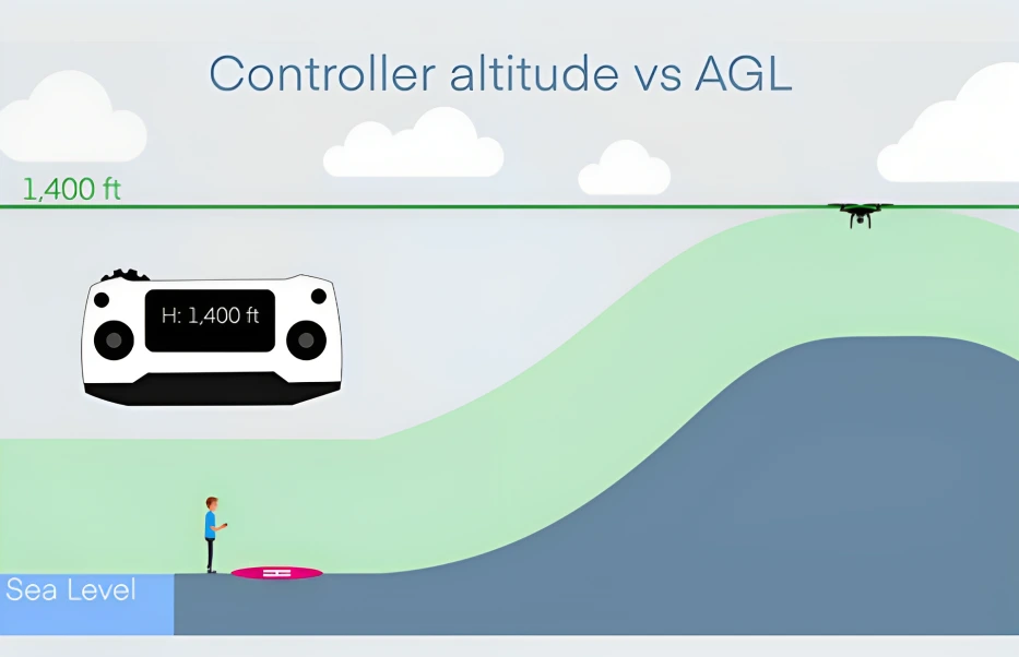
So, 400 feet on the controller is all good. Now, what if you fly forward? If you start to fly forward down on top of the valley right here, and you maintain that altitude, what is your controller going to indicate? It’s still going to indicate 400 feet. That’s the height above the takeoff point.
What does the FAA care about?
The FAA Federal Aviation Administration cares about the height above the ground. What is your height above the ground here? Well, we know because we know the design of the terrain right here and what it is. It’s 1400 feet AGL. We’re 1400 feet above the ground at that stage. Is that okay? It’s not.
Because the FAA says, in most cases, you can only fly up to 400 feet AGL. Even though your controller says 400 feet, it’s not the actual AGL.
Now you’re going to say, how do I know that I’m at 1400 feet or I’m not at 400 feet AGL? And the answer is it’s more complex. It’s complicated to figure out exactly where your Drone is in relationship to the ground because the ground keeps changing.
Now, if you live in Florida and you’re flying above the beach, it’s probably not that big of an issue. If you live in my area, where we have hills all around us, then it becomes more tricky to figure out what 400 feet is. It would be helpful if you did some research. You need to find out what the terrain looks like around you before you fly.
It would help if you estimated what 400 feet above the ground looks like. And then eventually, well, with experience, you’ll get used to it, but it’s a more complex, straightforward answer. You’re going to say, why is it that your Drone doesn’t tell you that? Well, your Drone needs sensors that can measure above the ground.
How high can I fly as a recreational flyer?
So, I’ll stop talking about this. Let’s move on to the next topic, which is how high I can fly as a recreational flyer. The answer here is pretty simple. Suppose you’re flying in Uncontrolled airspace. Uncontrolled airspace is away from airports in class golf airspace. Then, the maximum altitude is 400 feet above the ground.
We just mentioned that. That little green area that I showed you in the graph is where, uh, you have to stay within; you have to stay within 400 feet above the ground. Now, if you’re flying in controlled airspace near airports, you may end up in an airspace that requires authorization.
Now, if you’re a recreational flyer at this stage, you don’t know all of the different types of classification, but there are class B, class C, class D, and some parts of class E that require authorization. At that point, the maximum altitude depends on where you are. At that spot in the airport, it depends on the airspace around where you are.
So, if you take a look at this graph right here, this is an example of where I live. I live close to a Class D airspace, Class Delta, which is controlled and requires approval to fly. And if I go, I find this grid, which you can find on apps such as a Loft or before you fly, or here, the UAS facility map, and you can see that these numbers tell me how high I can fly in that airspace once I get approval.
So if you look right here, where it says 250 feet, 250 feet means that I can climb up to 250 feet above the ground and follow the terrain. As long as I get approval beforehand to use an app again, like a loft, we have videos that show you how to do this. So I’m going to put a link down there so you can see exactly how you do this, but that’s how you would figure it out.
So, in control of airspace, if you’re a recreational flyer, you can fly. Well, it could be zero feet. It could be 250 feet. It could be 400 feet. Now you’re going to say, what about at zero feet? What does that mean? It means that at that stage, you’re too close to the airport that you can’t fly if it’s a zero grid.
You can’t fly. You can’t even get approval to fly in there. It’s not available. There’s no waiver for recreational flyers, So that’s it. That’s as high as you’re going to be able to go, zero feet. You can’t take off. Okay? Another note about this: There are no waivers that are available to recreational flyers to fly any higher than 400 feet AGL at all times, So the max you’ll ever be able to go is 400 feet AGL.
That’s it. I know what you’re saying now because you may have heard somebody saying, well, if I’m within 400 feet of an obstacle, then I can fly more than 400 feet on top of it. Yes, but only if you are a part 107 pilot; this is only available under part 107. Okay. So, if you’re not a recreation, if you’re a recreational flyer, and you don’t have a part 107 certificate, you cannot fly 400 feet on top of an artificial structure or obstacle.
And use that rule. Even better, well, I don’t know if it’s better, but this is something that I always hear people are confused about because they say, well, if I take off from the top of a building, then I can fly 400 feet on top of that building, not as a recreational flyer, 400 feet AGL, the ground being the natural ground, not the top of a building, not the top of a car, not the top of a tower.
It doesn’t matter. Okay. So here we have an example. You have this building. This building is 200 feet tall. Now. You are, as soon as you take off, even though your controller is going to say zero feet, technically already 200 feet above the ground. So that means that you can only add another 200 feet on top of that.
Your controller can only read 200 feet max at this stage, and that’s it if you want to stay legal. All right. I wanted to make sure that all of this was clear because this is an area where we always find people—uh, making mistakes online when they, when they leave comments, uh, you can’t do that.
Part 107 Pilot
Okay, now the next thing is, what about part 107? You’re a part 107 pilot; how high can you fly? And It’s the same thing. You have to look at where you are. If you’re flying in controlled airspace, the maximum altitude is the width, which is the one that’s on the UAS facility map. You can get a waiver to fly higher than what is on the UAS facility map.
Remember that area that I showed you? 250 feet. Let’s say I wanted to fly 300 feet. I can do that. It’s called further coordination. You have to go on the FAA drones website, and then you can submit to fly up to 300, 400, whatever the FAA is going to approve you to do even if you are in a zero grid. As a part 107 pilot, you can still request to fly higher than the zero grid.
I’ve done that several times, and a lot of people do. You have to go to the FAA drone zone again and submit that request, and then you’ll be able to do that. This is not available for recreational flyers. You must do something other than that as a recreational flyer.
Airspace limit

If we go into airspace that does not need approval, the maximum that you can do is 400 feet AGL. Unless you are within 400 feet of a structure, and, at that point, you can fly as high as 400 feet on top of that structure, as long as it doesn’t take you into airspace that requires approval. Let’s take a look at this. Again, this is in uncontrolled airspace. You can do this. You can go right here.
Cell Phone Tower

There are 400 feet proper here; that’; how high we can fly typically feet above the ground. Let’s say that there is a cell phone tower right here that you want to inspect. It’s a 700-foot-tall cell phone tower. So now what? We have; as long as we stay within 400 feet of that obstacle of that tower, then we can fly within that entire green area right here.
So far so good? This is only true if you take off in airspace that does not need approval. I’m going to say that again. This rule applies only to Part 107 pilots and only if you are flying in an area that does not require approval. If you are flying in class B, in class C, in class D, or class E2, taking off, you cannot use this rule.
The altitude that you were given, the 250 feet or 100 feet, whatever it is, is absolute. It’s 100 feet above the ground or 250 feet above the ground. That’s it. You cannot use this rule. I want to make that clear because a lot of people need help understanding this section.
Example for better Understanding (Class E)
Let me ask you to think for a moment. Let’s say that, on top of that tower, There was a class E airspace starting at 700 feet. Can you fly your Drone right here in this area? I’m going to let the little Jeopardy music play in the background for a second. And what do you think? And the answer is yes, you can go in there.
You’re going to say, Greg, isn’t Class E controlled airspace? Yes, it is, but the FAA says that you only need approval to fly in Class E when it is primary to an airport starting at the surface.
Class E2
Class E2, for those of you who know your class, classes of airspace, Class E2 is the only one that requires approval. So, in this case, this is a class, uh, not a Class E2; this is a Class E starting at 700. In this case, you can enter this airspace without approval because, well, because the FAA says you don’t need approval to fly in there. Now, let me flip that question. What if, instead of a Class E starting at 700, we had a Class Bravo airspace that started at 700 feet?
Now, can you go and enter that airspace right here using the 400-foot rule that I just gave you? Again, right here. And the answer is only if you get approval to enter that airspace. Now, you’re trying to enter an airspace that requires approval from the FAA, in which case you would need to submit paperwork to do this.
Conclusion
Alright, give all these examples because these are all examples that we see online and we see in forums all the time. Now, if you want to do this, you can get a waiver, you can go on the FAA drone zone to do this, and you can also get a waiver to fly higher than 400 feet anywhere in the country.
You’re in Glasgow airspace, and Typically, you’re limited to 400 feet. You want to fly higher than that. You can go to the FAA drone zone, submit a waiver, and explain to the FAA what you’re trying to do. And then, well, and then they’ll let you fly. Okay. I hope this is clear. I hope this clarifies some of the information.
Frequently Asked Questions on How High a Drone Can Fly
Why are drones limited in their maximum altitude?
Drones are limited in their maximum altitude to prevent interference with manned aircraft, ensure compliance with aviation regulations, and maintain safety for both drone operators and other airspace users.
Are there different types of drones with varying altitude capabilities?
Yes, there are different types of drones designed for specific purposes, including recreational, commercial, and military applications, each with varying altitude capabilities. Military drones, for example, may have the capability to fly at much higher altitudes than consumer drones.
What happens if a drone flies too high?
If a drone flies too high, it may enter restricted airspace, pose a risk to manned aircraft, violate aviation regulations, and potentially cause safety hazards or accidents. Additionally, exceeding altitude limits may result in legal consequences for the drone operator.
Can drones fly above clouds or into the stratosphere?
Most consumer drones are not designed to fly above clouds or into the stratosphere due to limitations in their propulsion systems, navigation capabilities, and environmental conditions. Specialized high-altitude drones or weather research drones may be equipped for such missions.
What are some factors to consider when flying a drone at high altitudes?
When flying a drone at high altitudes, operators should consider factors such as weather conditions, airspace restrictions, battery life, signal range, navigation challenges, and regulatory compliance to ensure safe and successful flight operations.